Hiking in Zermatt
Zermatt's Summer Trails: From Alpine Meadows to Glacial Peaks
- Written by MX Zermatt
There are a number of Zermatt summer hiking and walking routes in and around Zermatt, with Zermatt being the starting point for a lot of these treks and excursions. These routes, a lot of which are ski runs in the winter are also ideal for mountain bike enthusiasts.
There are 400 km of summer hiking and walking trails around Zermatt, taking from 30 minutes to one or more days, going from gentle larch forests to the foot of millennial glaciers.
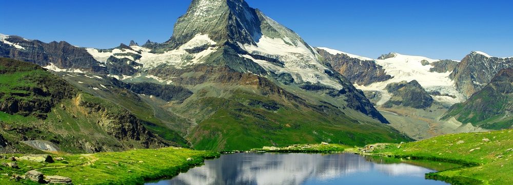
It is easy to set off the village and just follow the yellow signs that point to the various summer hiking trails. In no time you will find yourself in thick forests, alpine lakes, picturesque valleys, over hanging bridges, crossing mountain streams, past waterfalls, in the foot of glaciers!
Whether you set off for a casual hike to Smut or the steep hike to Edelweiss and further on to Trift, the scenery will never disappoint. Watch out for the local wildlife, the marmots, the chamois, or the deer who just might be in your path!
Alternatively, you can take one of the three lifts from Zermatt that take you up the different parts of the mountain (one way lift ticket will be required), walk around the various mountain stations and then head back down to Zermatt.
You can see below the panoramic summer map of area and mountains surrounding Zermatt with all trails numbered. Yellow signs in and around Zermatt will indicate the name of the path and direction to follow. As you can see on the map the trails are divided in four different categories:
- Green, easy walking trails suitable for everyone
- Orange, medium difficulty hiking trails that require a basic level of fitness
- Red, hard hiking trails that require advanced level of fitness
- Dotted red, red trials that are on high altitude and possibly on glacier

Trails are numbered and divided based on different areas of the mountains, Sunnegga and Rothorn, Gornegrat, Matterhorn Glacier Paradise, Trift, Täsch and Randa. The easiest and shortest trails are on the Sunnegga/Rothorn and Gornegrat areas where you can also benefit from using Sunnegga Express or Gornegrat Bahn to get up the mountain. On the Matterhorn Glacier Paradise and Trift areas trails are harder and longer. Also note that in the Trift area there is no lift and all trails start from the village.
Summer Hiking around Zermatt
Sunnegga – Rothorn
| 1 | Abenteuerweg: Rothorn – Ritzengrat – Tufteren | 1h40 |
| 3 | Blumenweg: Blauherd – Tufteren – Sunnegga | 1h20 |
| 4 | Direttissima: Tufteren – Tiefenmatten –Zermatt | 1h20 |
| 4a | AHV-Weg: Winkelmatten –AHV-Weg – Schönegg | 1h00 |
| 5 | Gamsweg: Rothorn –Kumme – Tufteren | 1h50 |
| 6 | Gourmetweg: Sunnegga – Findeln – Ried – Zermatt | 2h25 |
| 7 | Kristallweg: Rothorn – Fluhalp – Stellisee – Blauherd | 1h45 |
| 8 | Murmelweg: Blauherd – Stellisee – Sunnegga | 1h10 |
| 9 | Panoramaweg: Blauherd – Ritzengrat | 50min |
| 10 | Peak Collection: Rothorn | 30min |
| 11 | 5-Seenweg: Blauherd – Stellisee –Grindjisee – Grünsee – Moosjisee – Leisee – Sunnegga | 2h30 |
| 12 | Waldweg: Sunnegga – Tufteren – Patrullarve – Ried – Zermatt | 1h50 |
| 13 | Weg zur Freiheit: Rothorn –Oberrothorn | 1h25 |
Gornegrat
| 14 | Arvenweg: Riffelalp – Findelbach –Winkelmatten | 1h10 |
| 15 | Aussichtsweg: Gornergrat – Rotenboden | 40min |
| 16 | Bahnweg: Zermatt – Täsch | 1h20 |
| 17 | Gletschergartenweg: Riffelberg –Gletschergarten – Furi | 1h50 |
| 17a | Hängebrückenweg: Furi –Hängebrücke–Gletschergarten–Furi | 1h00 |
| 18 | Mark Twain Weg: Riffelberg – Riffelalp | 50min |
| 19 | Naturweg: Riffelalp –Grünsee – Moosjisee – Sunnegga | 1h40 |
| 20 | Riffelalpweg: Riffelalp – Ritti – Moos –Winkelmatten | 1h30 |
| 21 | Riffelseeweg: Rotenboden – Riffelsee – Riffelberg | 1h00 |
| 21a | Gletscher-Trekking: Rotenboden – Monte Rosa Hütte SAC | 4h00 |
| 22 | Sonnenweg: Gornergrat – Rotenboden – Riffelberg | 1h05 |
| 23 | Swiss Topwalk: Riffelalp – Riffelberg –Gornergrat | 3h00 |
| 24 | Weg der Stille: Gornergrat –Kelle –Grünsee | 1h45 |
Matterhorn Glacier Paradise
| 17b | Gornergletscher im Wandel der Zeit: Furi – entlang des Gornerbachs – Gletschergarten – Furi | 2h45 |
| 25 | Säumerweg: Trockener Steg – Gandegg – Furgg – Furi | 2h30 |
| 26 | Matterhorn glacier trail: Trockener Steg – Hirli – Schwarzsee | 2h00 |
| 27 | Hörnliweg: Schwarzsee – Hörnlihütte | 2h15 |
| 28 | Lärchenweg: Schwarzsee – Hermetje – Furi | 1h40 |
| 29 | Matterhorn Trail: Schwarzsee – Stafel – Zmutt – Zermat | 2h55 |
| 29a | Schönbielhütte: Schwarzsee – Innerer Stafel – Schönbielhütte – Stafelalp – Furi | 5h50 |
Trift
| 30 | Edelweissweg: Zermatt –Alterhaupt (Edelweiss) -Trift – Höhbalmen – Zmutt – Zermatt | 7h30 |
| 31 | Botanischer Lehrpfad: Zermatt – Trif | 2h10 |
| 32 | Wisshornweg: Zermatt–Schweifinen–Wisshorn–Trift–Zermatt | 6h40 |
| 33 | Platthorn/Mettelhorn: Zermatt –Alterhaupt – Trift– Furgji – Platthorn/Mettelhorn | 5h20 |
| 34 | Rothornhütte: Zermatt –Alterhaupt – Trift– Rothornhütte | 4h40 |
Summer Hiking around Täsch and Randa
Täsch
| 41 | Arigscheis | 4h10 |
| 42 | Rundwanderung | 1h10 |
| 43 | Panoramaweg | 1h25 |
| 45 | Täsch – Täschhütte | 3h25 |
| 46 | Täschalp – Pfulwe – Fluhalp | 4h55 |
| 47 | Täschalp –Weingartensee | 4h40 |
| 48 | Täschalp – Tufteren | 1h45 |
| 49 | Täschalp –Kinhütte | 3h05 |
Randa
| 60 | Dorfwaldweg | 1h20 |
| 61 | Weisshornhütte | 4h30 |
| 62 | Domhütte | 4h30 |
| 63 | Gross Kastel | 3h40 |
| 64 | Schaliberg | 3h45 |
| 65 | Kreuz | 1h45 |
| 66 | Waldweg | 2h20 |
| 67 | Kinhütte | 3h30 |
| 68 | Europahütte | 3h45 |
| 69 | Rundweg Hängebrücke | 4h |
For more information and details on various popular hiking trails please visit the relevant Zermatt Tourism page.